|
|

Root with a Lot of Use, AT, Maine
|

New Ladders, AT, Maine |
Maine
has a few ups and downs. Natural ladders and man-made ones
help the climbs. |

Mahoosuc Notch, AT, Maine
|

Mahoosuc Notch, AT, Maine
|
One
of the first sites in Maine is Mahoosuc Notch. You crawl over,
under, and around rocks filling the notch. |

Mahoosuc Notch, AT, Maine
|

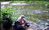
K in Mahoosuc Notch, AT, Maine
|
|

Pack in Mahoosuc Notch, AT, Maine
|

Grouse, AT, Maine |
The
wildlife can be friendly. |
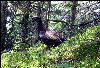
Grouse, AT, Maine |

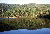
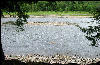
Speck Pond, Clouds, AT, Maine
|
Speck
Pond offers tenting and swimming. |
Speck Pond, AT, Maine |

K Packing, Andover, AT, Maine
|
Andover
offers a couple of places to stay, as well as big breakfasts.
|

Hiker's Breakfast, Andover, AT, Maine
|

K and AT Sign Bald Pate, AT, Maine
|
|

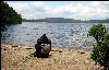
Swim Hole, AT, Maine |

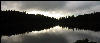
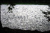
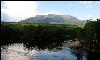
Pond with Moon, AT, Maine
|
Maine
has many lakes and places to swim. |

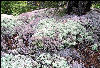
Lined With Flowers, AT, Maine
|

Sundews, AT, Maine |
Wildflowers
abound during the summer. |

Pitcher Plants with Water, AT, Maine
|

New Tent, AT, Maine |
|
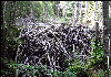
Forest of Lichens, AT, Maine
|

Lined with Flowers, AT, Maine
|
|

Rawpower, AT, Maine |

Ken Climbing, AT, Maine |
Rawpower
was thru-hiking the trail. |
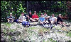
Boy Scouts, AT, Maine |

Moose Tracks, AT, Maine |
The
Boy Scouts were section hiking. |

Water Not Tested Sign, AT, Maine
|
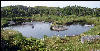
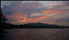
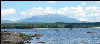
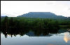
Pond and Clouds, AT, Maine
|
|
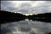
Pond and Clouds, AT, Maine
|

Piazza Rock, AT, Maine |
Piazza
Rock defies gravity. |

Thru Hikers, AT, Maine |
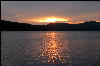
Pond Sunset, AT, Maine |
|
Mountain Pond, AT, Maine
|

The Walking Man, AT, Maine
|
The
Walking Man was hiking the trail again. |
Baseball Bat Shelter, AT, Maine
|

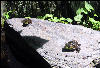
Frog, AT, Maine |
The
Poplar Ridge Shelter features the old style baseball bat design. |

Crocker Cirque, AT, Maine
|

Trees and Sunlight, AT, Maine
|
|

K in the Mist, AT, Maine
|

Blaze Mark, AT, Maine |
|

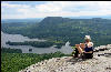
Horn Pond, AT, Maine |
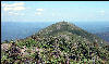
Avery Peak, AT, Maine |
The
Bigelows were saved from a ski area. Avery Peak offers sunset
views. |
Sunset, Avery Peak, AT, Maine
|
Sunset, Avery Peak, AT, Maine
|
|
Sunset, Avery Peak, AT, Maine
|
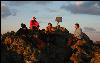
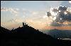
Trail Crew, Avery Peak, AT, Maine
|
Volunteer
trail crews maintain the trail. |
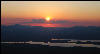
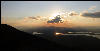
Sunset, Avery Peak, AT, Maine
|
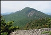
Avery Peak, AT, Maine |
|
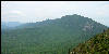
Bigelows, AT, Maine |
2000 Mile Sign, AT, Maine
|
The
2000 mile marker on a road crossing. |

Mushrooms, AT, Maine |
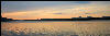
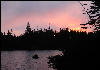
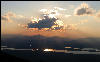
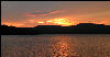
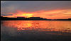
Sunset, West Carry Pond, AT, Maine
|
West
Carry Pond is one of several ponds that offer sunset views.
|
Sunset, West Carry Pond, AT, Maine
|
Sunset, West Carry Pond, AT, Maine
|
|
Sunset, West Carry Pond, AT, Maine
|

Deer, AT, Maine |
|
Sunset, Pierce Pond, AT, Maine
|

Braveheart, AT, Maine |
Braveheart,
a thru hiker, nearing the end. |
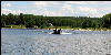
Kennebec Ferry, AT, Maine
|
Kennebec, Low Tide, AT, Maine
|
The
official trail is the ferry across the Kennebec River. The
river goes up and down depending on the status of the upstream
dam. |
Kennebec, High Tide, AT, Maine
|
Beaver Dam, AT, Maine |
|

Keith Senior, Shaws Boarding House, Monson,
AT, Maine |

Keith Junior, Start of 100 Mile Wilderness,
AT, Maine |
Keith
Junior has taken the reins from Keith Senior at Shaw’s
Boarding House. |
Frogs, AT, Maine |

Frogs, AT, Maine |
|

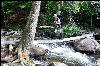
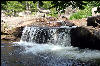
Wilson Falls, AT, Maine |

Wilson Falls, AT, Maine |
Wilson
Falls is one of the highest falls in Maine. |

Wilson Falls, AT, Maine |
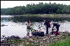
L Preparing to Ford, AT, Maine
|
You
cross several streams in Maine. No bridges – you just
have to ford them. |
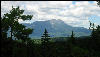
L at Overview, AT, Maine
|

Frog Making Noise |
|

Down Fourth Mountain, AT, Maine
|

Pitcher Plant, AT, Maine
|
|

L on Chairback, AT, Maine
|

Ford at West Branch, AT, Maine
|
|
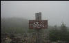
Fog on White Cap, AT, Maine
|

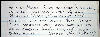
Register of 79 year old woman, AT, Maine
|
All
ages walk the trail, as shown by the register entries. |

Moose Pop, AT, Maine |
Register entry for son of 79 year old
woman, AT, Maine |
|
Sandy Beach, AT, Maine |

Squirrel, AT, Maine |
|

End of day reflections, AT, Maine
|

Fort Relief, AT, Maine |
There
is a privy competition in Maine. |

Squirrel and Pack, AT, Maine
|

Potty, AT, Maine |
|
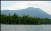
Katahdin, First View, AT, Maine
|
White House Landing, AT, Maine
|
The
White House Landing offers showers and food seventy miles
into the Hundred Mile Wilderness. |

White House Landing, Laundary, AT, Maine
|

Katahdin and Pack, AT, Maine
|
Katahdin
can be seen many miles away. |

Rainbow Springs Shelter, AT, Maine
|

Mount Katahdin, AT, Maine
|
Rainbow
Springs shelter was featured in National Geographic. |
Mount Katahdin, AT, Maine
|

Moose, AT, Maine |
|
Mount Katahdin from Abol Bridge, AT,
Maine |
Mount Katahdin, AT, Maine
|
Abol
Bridge terminates the Hundred Mile Wilderness. From there,
you hike into Baxter State Park. |
L on Bridge, AT, Maine |
Waterfall, AT, Maine |
|

Tree on Rock, AT, Maine |
Mount Katahdin, AT, Maine
|
|

Final Sign, AT, Maine |

Katahdhin, AT, Maine |
The
last hike can be done in almost any weather, unless the mountain
is closed. |

K at the Top, AT, Maine |

Last Pair of Boots, AT, Maine
|
Finally,
it’s the end. - Mount Katahdin |
|
|
|