|
Return to Appalachian Trail Home
Page

Bulls Bridge, AT, Connecticut
|

Indian Pipestem, AT, Connecticut
|
Bull’s
Bridge was built in 1842. |

Lizard, AT, Connecticut |

Snake, AT, Connecticut |
Connecticut
offers a variety of wildlife. |

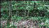
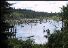
Rocks, AT, Connecticut |

Pond, AT, Connecticut |
|

Relaxing at Silver Hill Campsite, AT, Connecticut
|

Germanium, AT, Connecticut |
The
Silver Hill Campsite features a swinging chair. |

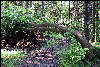
Narrow Trail, AT, Connecticut
|
Lime Rock Racetrack, AT, Connecticut
|
You
pass through narrow trail. The Lime Rock Racetrack can be inviting
or an annoyance. |

Friendly Wildlife, AT, Connecticut
|

Iron Bridge, AT, Connecticut
|
The
Iron Bridge goes over the Housatonic River near Falls Village.
|
Dry Great Falls, AT, Connecticut
|

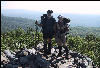
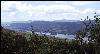
Resting at Rand's View, AT, Connecticut
|
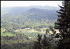
The
Great Falls on Housatonic River, flows over a 60 foot ledge.Unfortunately,
the falls were dry. Rand’s View offers vistas from the edge
of a field. |

Rock, AT, Connecticut |
Resting boots, AT, Connecticut
|
|

Mushrooms, AT, Connecticut |
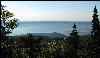
View from Riga Leanto, AT, Connecticut
|
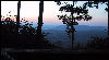
The
Riga Leanto offers a view of the sunrise without getting out of
bed. |
Bear Mountain, AT, Connecticut
|
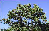
Tree, AT, Connecticut |
Bear
Mountain (2,316 ft.) is the highest peak in Connecticut. It is
not the highest point in Connecticut. |

CT, MA Border, AT, Connecticut
|

Sages Ravine, AT, Massachusetts
|
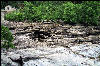
Sages
Ravine contains a series of falls and cascades. |

Tent at Sunset, AT, Massachusetts
|

Sunset,AT, Massachusetts |
|
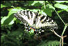
Butterfly, AT, Massachusetts
|

Shay's Rebellion, AT, Massachusetts
|
Shay's
Rebellion, occurred when Patriots revolted against the federal
government. |

Tree with Mushrooms, AT, Massachusetts
|

Tent with a View, AT, Massachusetts
|
|

Sign to Georgia, AT, Massachusetts
|
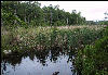
Swamp, AT, Massachusetts |
The
trail passes many ponds in Massachusetts. |

Sign, Going Both Ways, AT, Massachusetts
|

Benedict Pond, AT, Massachusetts
|
|
Tyringham Shaker Village Remains, AT, Massachusetts
|

Flag Irises, AT, Massachusetts
|
Tyringham,
was a Shaker Village from 1782 until the spring of 1875. |
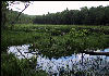
Swamp, AT, Massachusetts |
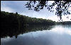
Upper Goose Pond, AT, Massachusetts
|
Upper
Goose Pond offers swimming and boating. |

Upper Goose Pond with Clouds, AT, Massachusetts
|
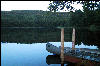
Upper Goose Pond, AT, Massachusetts
|
|

Over the Mass Pike, AT, Massachusetts
|

Truck on the Mass Pike, AT, Massachusetts
|
You
cross over the Mass Pike on an overpass. |

Trail in the Water, AT, Massachusetts
|
Swamp, AT, Massachusetts |
|

Privy Door, AT, Massachusetts
|

Sign at Dalton, AT, Massachusetts
|
|

Dalton Home Stay, AT, Massachusetts
|

Lake, AT, Massachusetts |
You
can make yourself at home in Dalton. |
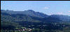
Mountain view from the Cobbles
|

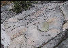
Rocks with Quartz, AT, Massachusetts
|
The
Cobbles is a marble rock outcropping that overlooks Cheshire.
|
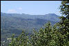
View of Greylock, AT, Massachusetts
|
Rock, AT, Massachusetts |
You
also get a view of Mount Greylock, the highest peak in Massachusetts. |
Mount Greylock from the Cobbles, AT, Massachusetts
|

Azalea, AT, Massachusetts |
If you
hike at the right time of the year, the flowers are in full bloom.
|

Flowers, AT, Massachusetts |

Flowers, AT, Massachusetts |
|

Rock, AT, Massachusetts |

Leland Memorial, Chesire, AT, Massachusetts
|
The
LeLand Memorial honors the man who brought Thomas Jefferson a
giant Cheshire Cheese. . |
Low Bridge, AT, Massachusetts
|

Flower, AT, Massachusetts |
|
Hazy Valley, AT, Massachusetts
|

Flower, AT, Massachusetts |
|

AT Sign in Stone, AT, Massachusetts
|

Tower, Mount Greylock, AT, Massachusetts
|
|
Elevations sculpture, Mount Greylock, AT,
Massachusetts |

On the Road, AT, Massachusetts
|
The
trail follows a road, a more infrequent occurrence these days. |

Over the River, AT, Massachusetts
|
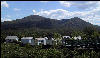
North of Mount Greylock, AT, Massachusetts
|
|
÷ ÷ ÷ ÷ ÷ ÷ ÷ ÷ ÷ ÷ ÷ ÷ ÷ ÷ ÷ ÷ ÷ ÷ ÷ ÷ ÷ ÷ ÷ ÷ ÷ ÷ ÷ ÷ ÷ ÷ ÷ ÷ ÷ ÷ ÷ ÷ ÷ ÷ ÷ ÷ ÷ ÷ ÷ ÷ ÷ ÷ ÷ ÷ ÷ ÷ ÷ ÷ ÷ ÷ ÷ ÷ ÷ ÷ ÷ ÷ ÷ ÷ ÷ ÷ ÷ ÷ ÷ ÷ ÷ ÷ ÷ ÷ ÷ ÷ ÷ ÷ ÷ ÷ ÷ ÷ ÷ ÷ ÷ ÷ ÷ ÷ ÷ ÷ ÷ ÷ ÷ ÷ ÷ ÷ ÷ ÷ ÷ ÷ ÷ ÷
|
Links
Appalachian Trail Conference
Appalachian Long Distance
Hikers Association (ALDHA)
|